Sleep well overnight. Breakfast: buffet. Fine in quantity and acceptable in quality. Plenty of coffee and more cake than I could eat. I always feel I've let down a buffet if I can't scoff the lot. Amy discovers "BlueFi" app that allows you to use your phone's BT as a walkie-talkie, so we'll try that to mitigate lack of wiring. Grey skies outside but no rain; off for our "early morning" outing at 9:30 - hands on time; not M1 "turn up about then and faff a lot" time. Chris "sick man of Europe" Wood still sick but will be spotter in the launch.
Outing: front-stops work most of the way down, some bursts on the way back, and 4 * 500m pieces on the second way back, clearly I've forgotten something. In general it went well, though lacking the oomph of the full IM3 VIII. Others out in the Quad. Will coxes with a megaphone.
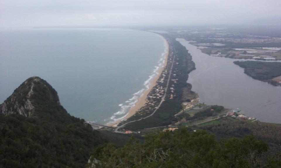
Now its lunchtime, but I rather fancy the run along the beach and maybe a shot at the prominence at the end. So elect to skip lunch, it is but food, and head off. Over the bridge over the lake, turn left, and almost immeadiately there's a side path down to the beach. Which is sandy, and empty. To my right the sea, to my left the quite tall and quite uniform dune about 20-30 feet high, with houses spaced out and the odd quiet bar. I follow vehicle tracks for a km trying to find some firmer sand, then head down to just above the sea and its better there. Steadily eat up the km, though not quickly, stopping every km for a pic as the hill gets closer. The beach is longer than it looks, and my watch shows 6 km by the end. Trend up, over a little road bridge over the exit canal, and where the road swings left I continue straight up a stony track. Just on the end is an old fort, which wiki said was to guard the canal. After about a km of gently rising track the "red path" turns uphill and continues straight up the hill side with neither zig nor zag; I start up jogging but am soon reduced to a walk. Its steep enough to need care and moving from one footrest to another on the slippery soil. About 2/3 of the way up there's a break in the trees - otherwise I can see no distance - and the path starts zigging; and just when I'm wondering if I'm going to have to turn back a little more push gets me to the top. 541 m says wiki, which I'll take over the just-less-than 500 that my GPS offers me. Great views, back over the lake and into the distance, and over the summit down to the far side, whatever that is. Look around but there's no rest for the wicked so head off down. There's a tempting "yellow path" that I suspect would be friendlier, but I can't be sure where it goes so stick to what I know. I don't run down but I do bounce from tree to tree. And so to the "easy" track, and then to the road, and take the road rather than the beach. easier but more boring, especially since its tree lined and I can't see lake or sea. GPS gives out at 14 km with 4 km to go, and running that last 4 km was quite hard.
But I get back only a little late, in time to leap in and cox the afternoon outing, which went fairly well. Same exercises, Dan still stroking, Will in at 6 with great enthusiasm, and James in the launch again.
Finish around 5, shower there, head back quite slowly, lie down for a bit, go down for pre-dinner drinks with Brian and Amanda and Chris; some others turn out to have been out on the town. Dinner: mushroom risotto is good, followed by decent pork and roast potatoes; and a choux pastry.
Then its time for a bit of video watching, and pore over the mornings outing. To my surprise I'm still over-reaching at the catch, because I thought I'd carefully backed off, but no. That's rather interesting; clearly I need to back of even further. And I also need to watch out for going in ahead of Dan, especially at 30.
No comments:
Post a Comment