Sunday 28 July 2019

France 2019: Argentiere

[Previous: Chamonix: rest day | Couvercle and Pointe Isabella] [Notes]

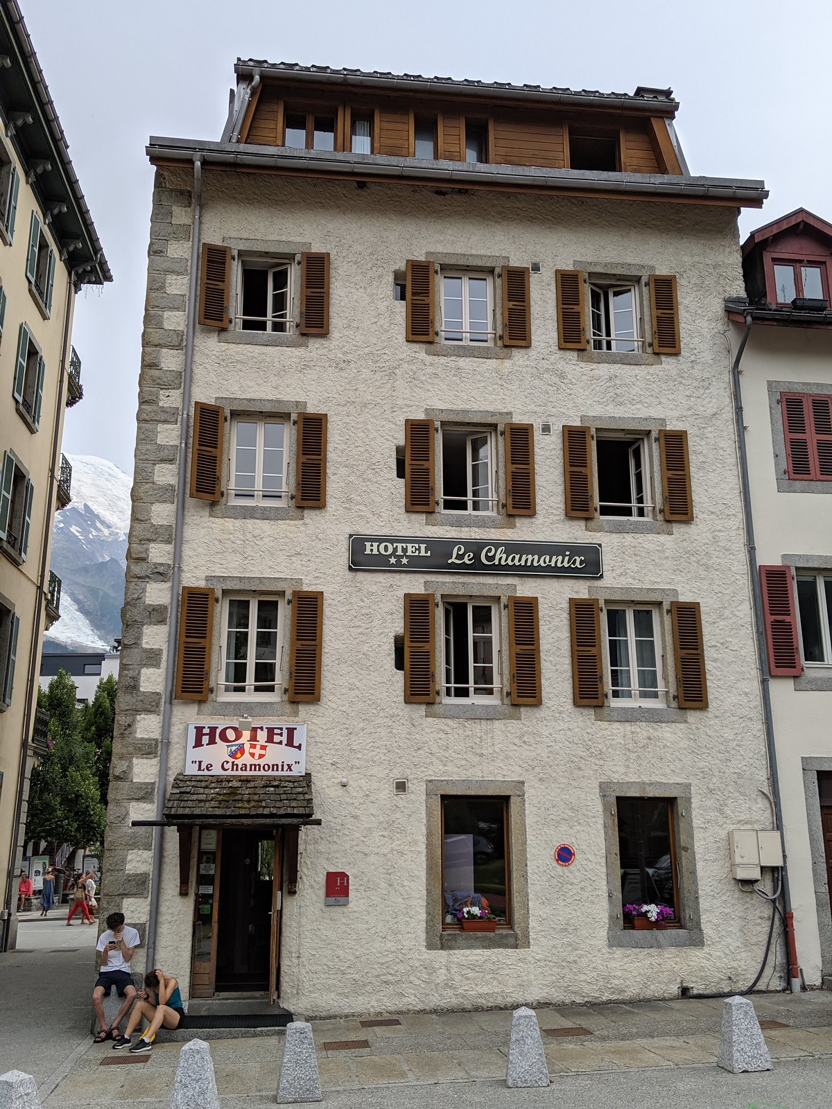
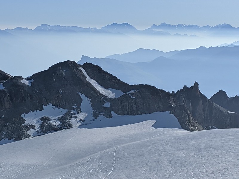
After Pointe Isabella the official timetable was vague; we had a notional middle week - actually more like 5 days - to do "something". Originally this was to be "go up somewhere" but at this point "rest somewhere" seemed like a rather pleasant alternative, and what are plans if not flexible. Also if my pictures don't lie, the weather went wet for a while. And so we found an apartment in Argentiere (ground floor middle), from the night of 7/29 to morning 8/1. It was fine; I didn't bother with formal pix as it was a "ski appt generic"; here's one of D and his characteristic feet.

Most of the text here is from quick notes I took at the time.

7/28 Sunday: down in Chamonix - actually Argentiere - after a week mostly up, except one rest day. That was good but hard and I feel well used and stretched. Today - Sunday the 28th - was a day of rain which was fine. Up 9ish b'fast slowly on what we super-u'd y'day and MED went out for croissants etc. Outside medium rain continues and mist shrouds the trees.

Note: pix with some captions on fb.

Our appt in the Residence Grand Roc proves adequate to our first night. We get the double, E the single upstairs with us and D the sofa which he doesn't bother xform into a bed. It's nice to get on well enough with each other for this not to rub. 12:30 go out to buy stuff for lunch but discover super has just shut so get at marche: E 15 of olive pate - a slight overbuy perhaps though it proves good - carrots tomato sliced ham saucisson sec a goat cheese and a big block of Tomme for only E 5. And a flute from the bread man.

14:30: coffee and prevarication done so head out to Martigny to see the tower cos I've passed it by too often. And it's a trip of about the right size. More cloud higher up (return to get passports; comedy trying to leave appt car park) Montets Forclaz border no guards Martigny park walk up to tower. Abeilles on way up. It's only about ten mins. No entry formalities or staff and we can climb right up. Bare stone wood stairs views good. Inside D and I puzzle over odd two storey room in tower side before realising it is a fireplace. Back via paths. Walk to river old wooden arched bridge church small ex voto. Back. Pic: D and E on the top.

MVIMG_20190728_162010

Soir: decide to eat in. Just enough bread. Quiet reading.

7/29 Monday: up at the unearthly hour of 8:30 though actually I also got up at 4:30 as my phone alarm was set and downstairs. B'fast sit then to shops for bread coffee etc. Also looking for Chamonix crags guide. Bureau des guides not open till 5 and tourist not useful but total-liquidation has a (sadly undiscounted) copy for E 27. Back more food off about 11 I think head up to Col Des Montets then back a little park and track just opposite. There's a cluster of boulders we pick Le Transat whick book says is most pop N face is in shade some Spaniards there. Have a play... E does 3c r2 I do 4c r3 D does a harder 4c. Put top rope on and E and I do the slightly longer central 4c and I think D does the 5b r7. Go round to W face lovely by little stream bucolic as book says. 3c r1 to R I do and E does with a little push on her bottom. 4c r7 to L then D fights up the 5c r4 central.

MVIMG_20190729_135302

Time for coffee. Up to Aig Rouge accueil who do drinks and ice creams and a choc bar and a nice terrasse for cards for an hour or so. Wx is fine: sun but coolish with wind and evap of last night's rain.

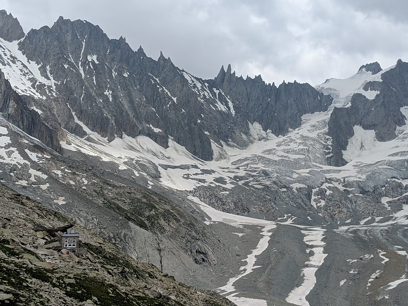
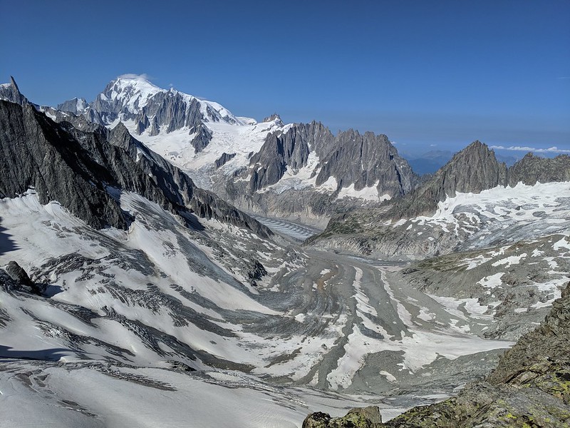
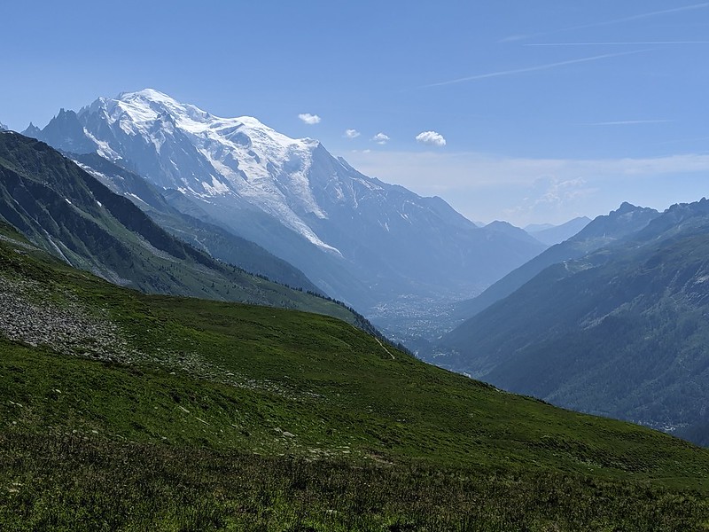
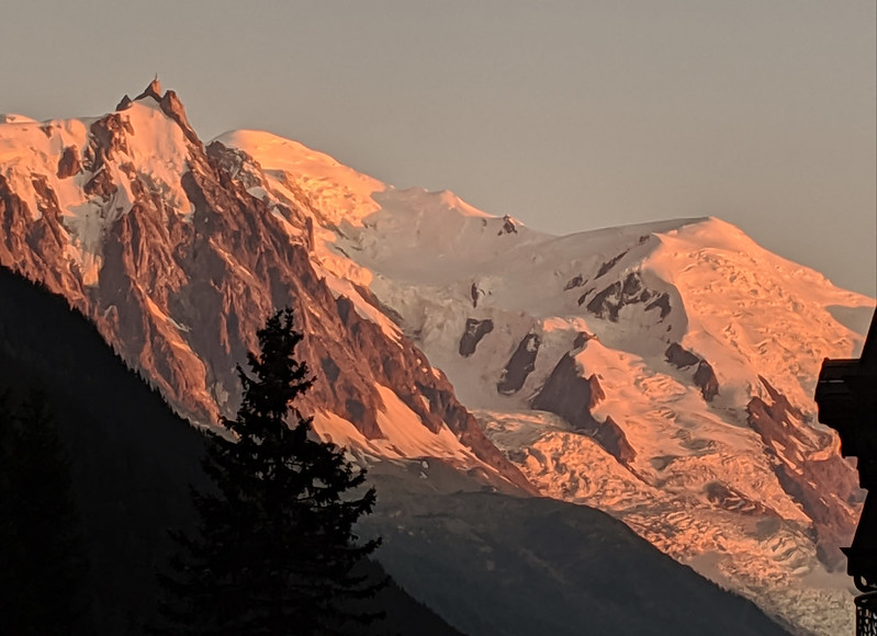
Down other side not far - not as far as le Buet - to railway tunnel boulder park by road (this I think is a pic of where to be to find the rock... or this; it's not obvious from the road; GPS trace of return) hard 3c nice also hard 4c top rope and top rope D on several attempts at 6a. Home and the out to Pet'te Verte v good esp E's Perigoudian (gizzard!) and D's summer salad - smoked salmon. And views of Mont Blanc on the walk back to our appt.

MVIMG_20190729_210443

7/30 Tuesday: again 8:30 slow b'fast sun outside.

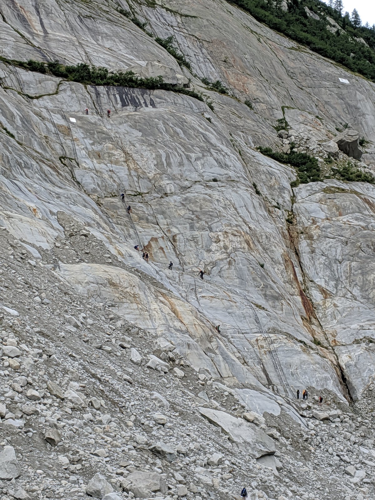
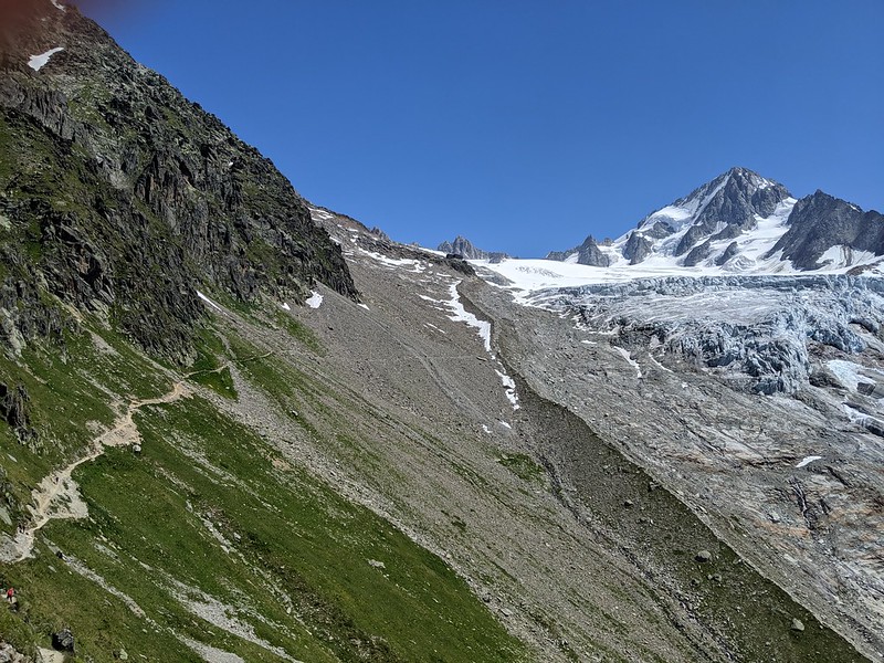
Rocher de Saix (signpost; GPS trace): 85m 4c good quite scary as lead and DE's first real multi-pitch. Hard to get a good pic; here's a not-so-good one. From the top there's effectively a via ferrata to walk-off (GPS trace); notice that we are still clipped in.

MVIMG_20190730_173958

And the walk through the pine woods is pleasant. Just after the woods, nad before you get back down to the campsite-road, there's a little bit of fields-slowly-returning-to-nature where the stones have been collected into walls in the patience years of yore; I'm almost certain this is where I slept, years ago, when on the CG125 to Vienna.

Soir: galettes / crepes.

7/31 Wednesday: light day. Up to Col de Forclaz for little walk nearly level to the buvette [GPS trace]. Cool mostly in shade alongside the bisse. Panels tell us the glacier was formerly exploited for ice but it has retreated a lot since the and the tongue pants easy up above. Pines, running stream, shade and a vin rouge while we play cards. And we share two pieces of apricot tart.

MVIMG_20190731_122807

Back to col for cafe and M has E30 salad forgetting sf is 1-1 with Euro but it is good. More cards: I think I just edge ahead of  D.

MVIMG_20190731_143048

Down to Tete Noire and finally stop for its advertised "gorges mysterieuses". Or rather the top thereof: the path goes down down and we don't though I'd like to some time.

Soir: La Remise.  Good but pricey prob worth it.

8/1 Thursday: up 7:30 to get croissants bread b'fast and then packing and cleaning and finding and sorting. Pic; Bar "Le Savoy" which I include because I think I remember it from the first climbing trip here oh so many years ago. Off 9:45. That completes our rest period, it's time to get mountaineering again!

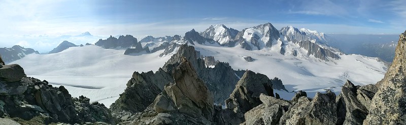
Down the valley to St Gervais les Bains, well actually it is St Gervais - Le Fayet in the valley. Park the car (with, I recall, some slight difficulty, ending up just outside the cemetery in the Chemin du Casino; but there was plenty of space there). And so we say goodbye to M. We're off up Mt Blanc, and she does not much care for the snow and ice, so will take the train back home. I wave her off.

MVIMG_20190801_115931

Thursday 25 July 2019

France 2019: Couvercle and Pointe Isabella

[Previous: Chamonix: rest day] [Notes]

7/25 Thursday: back up to the mountains (GPS trace: Montenvers to Couvercle). Linger a little over b'fast so don't get the early train (8:30) and the 9:00 train is crowded, but we have our tickets and place in the queue so it is fine. Head off at 10:15 says the GPS, and since I'm writing this in May 2020, I'll trust it's memory better than mine (also I have a few notes). It is all utterly glorious, although arguably the Mer could do with a little more covering. We follow the trail off right; don't be confused by the cable cars that go down to the ice grotto.

MVIMG_20190725_094822

Despite the warning signs the moraines are, if I recall correctly, OK if large. They can't have been bad as I didn't bother take any pix... (ah but I did coming back) before the moraines there's a path descending for a bit, then some fairly long ladders. And so we head up the ice. I struggle to recall if we put crampons on at this point. I have a feeling that M did, but I was hard and didn't.

MVIMG_20190725_105721

There's a bit of a canyon down the center which can be used for practising ice climbing with top rope, if you have time and energy. We didn't.

MVIMG_20190725_111536

Route finding - on a clear day - is not difficult. We're going to Couvercle, but Charpoa shares the ladders.

MVIMG_20190725_114315

From here, it's a hike across rubble and a scrabble up some junk to... the Ladders of Death! Time now 12:20. Not as bad as I'd feared (but I had secretly been quite worried, so don't let me give you the impression that they are Nothing). They aren't vertical, for a mercy.

MVIMG_20190725_123605

There's one big section of ladders, then some grassy shelves and stuff, and a route off towards Charpoa, but there are signs so it would be hard to go wrong - in decent viz. The Maison de Montagne describes them as 320 m of ladders, but it isn't - by GPS, the first main section is "only" 110 m, then the steep grass, them maybe 50 m more. We didn't rope up. We did put harnesses on in case we might want to, and we had slings to hand in case we wanted to clip on, but I don't any of us did at any point.

Look closely and you'll see M, D and E:

MVIMG_20190725_145344

Still quite a lot of climbing to do, though. Then you kinda round a shoulder and get some views N; here (I think) is the Dent du Geant living up to its name.

MVIMG_20190725_155551

At last the refuge heaves into view, and the cirque (better view of cirque). Pointe Isabella is top right. The refuge you see is the new hut. The old one was underneath the huge tilted rock, hence the name "couvercle" for frying-pan lid. Just over 6 hours total, more than 900 m elevation gain - M was getting fairly tired towards the end.

The hut has character, which is nice, except... well I'll come to that later.

Before it gets dark: explore to find the route down to the glacier. The "obvious" path: head past the old refuge and follow faint tracks doesn't work and ends with an old rope; probably the glacier has retreated too far. Ask at the hut and discover you have to go back down the track a ways to a yellow stick... and find this, further down than I expected.

MVIMG_20190725_155640

7/26 Friday: attempt on Pointe Isabella (GPS trace). TL;DR: fail but close. Up 4:30 b'fast leave 5:30 down where I explored y'day to col on moraine down along yellow poles then we're on our own and after the usual brief flailing we're onto ice then snow then gear up. Here we are off the moraine as light begins.

MVIMG_20190726_055107

Brief screeching over scoured flattish rocks then pure snow up up. But it's a long way and we shed 150 m going down. Over some big mostly bridged but still quite disturbing crevasses: progress carefully well spread out. Here we're nearly finished with the approach and about to start the route: straight ahead is the icefall which we naturally avoid; we go straightish up the snow then take the ramp R to follow the snow ramp up the rock buttress...

MVIMG_20190726_075354

Thence up towards the first snow ridge (not quite visible in this pic) where the guardienne had warned of "glace" - from someone who had done the route a week ago and we've seen little traces - and yes there's about 15 m of 50 deg ice so pitch it cut some steps and put in an ice screw all quite exciting really. Takes an hour and effort though. From the top of the first ridge, we can look back to the herring Mer, across it to Envers, and of course Mt Blanc capped with a little cloud.

MVIMG_20190726_101010

Sun on ridge. Up to rock ridge (views of icefall; view on the way down) up that second snow ridge the rock again and we're on the summit slopes but late. Stop at noon maybe 100 m short but f'cast is storms pm and we want to be below difficulties by then, because we're a little un-nerved by that brief ice pitch. And, Miranda is sensible. D and E model Rab.

MVIMG_20190726_120404

And the view from D's eyes.

MVIMG_20190726_120255

Down. Crampons off for longer rock but as usual hard to be sure it is worth it (D and E descending a rock ridge, not sure which one; and on one of the snow ridges). Carefully down ice me last E "falls" once D not and thankfully me not. Here's the icefall with the weather somewhat ominously closing in.

MVIMG_20190726_140006

Down carefully crevasses then snow some uncertainty as to track nearly miss path over scrapey rock which E does not like. Rain then hard hail kicks in as we're leaving moraine - again track on rock marked with square but recommended track over moraine not marked. Hut, whew. So we could perhaps have pushed on to the summit, at the cost of getting hailed and rained on quite a lot on the glacier; but some caution is good. Here we're on the last of the snow, with the hut visible opposite if you look closely.

MVIMG_20190726_154129

"Add complaint re party here" say my notes. Yeah. So after a pleasant afternoon and meal - at which we were the only guests - we go to bed as good hut-guests do before 10; but then the sound of karaoka comes from downstairs... WTF... eventually I go to investigate / complain but the hut folk (for it is they) are unapologetic and there is nothing to be done. A poor show, but that's Johnny Foreigner for you.

7/27 Saturday: down to the valley (GPS trace with geolocated pix; note the huge jump in the middle is not real) up with alarm 7. Feckless hut folk are unsurprisingly late getting b'fast so pack a bit and look outside waiting. The early light is interesting; our route is down to the moraine, up the LHS snow stripe, round to the L to avoid the wall, then up the snow diagonally R as seen here.

MVIMG_20190727_071550

Pano. View of the old hut under it's rock. Hut cat. Let M handle conversation. What lots of people do from here is this: l'Aiguille du Moine, a pure rock route. A pile of people were heading out to it the morning we tried Isabella.

MVIMG_20190727_084333

Head down 8:30 and it takes 4+ hours: could be done faster but it is a long but interesting way. Wonder if going via glacier might be better. Don't stop to play on ice cos E's f'cast says rain later and indeed when we get to Montenvers it does start. Here are the ladders down (or in our case up) from the Mer to Montenvers. It's hard to sense the scale but these by comparison with the Couvercle ladders are comparatively short.

MVIMG_20190727_120444

Cafe then train down. Car still there - run through rain - up to Argentiere to get keys to appt and settle in. Soir: local pizza.

Wednesday 24 July 2019

France 2019: Chamonix: rest day

We come down from the Albert Premier around 16:00; it's hot in the valley. Later we discover this is "le canicule". We drive down through Argentiere to Chamonix, and after a little road comedy - it turns out that we can go in the barred road, which on closer inspection says "access to hotels only" - we arrive at the Hotel Le Chamonix.

MVIMG_20190724_192635

It (really) doesn't have a car park but it does have showers, and having used those I drive the car off to le Biollay which the hotel recommends (see "practical information" for more) and am (as I belatedly realise) lucky to get a space there. Walking back is about 10 minutes and pleasant. We go round the building to the (unrelated) Bar Le Chamonix and play Big 2, the game of the holiday; read and write up. 19:30. Evening meal: to Le Serac, randomly selected from restos on the strip; we didn't fancy the Chinese because three of us were barefoot. Le Serac doesn't blink an eye when we play cards and the food is decent, but not cheap.

Taking pictures of Chamonix is for the tourists, and we're Serious Mountaineers, so I don't.

My original plan had been for a rest just overnight in the valley. But we're all feeling like we could do with a day off. So M phones the next hut - Couvercle - and shifts our booking by a night; and we then discover that Le Chamonix can accomodate us another night; so we're all set for a whole day and two nights off.

2019/07/24: Wednesday: day off. Still very hot; do precious little all day except relax in the shade, though M and I go for an earlyish morning stroll up the river getting perhaps half way to La Praz before it becomes too hot. Before b'fast go off to the car to retrieve map+guide, and check that all is well: it is. There's even a sort of "overnight guard" in the carpark, in that someone's old VW camper with the pop-up tent is set up.

MVIMG_20190724_143018

View from the bar towards the local church. Note that the fan is not just blowing air, it has a water feed from the tube and was sending out a delicious cooling light spray of water droplets. E explores town and later returns with tales of the vast rank upon rank of outdoor shops. D is more stay-at-home. I read Bagehot.

At some point I go to visit the Maison de Montagne / Bureau des Guides which is just next to the church, but don't find it very sympa. They do show me a pic of the ladders up to Couvercle, which seem a bit worrying, but I internalise this and don't bother anyone else. As it turns out, they were fine.

MVIMG_20190724_154429

Evening meal: to the Chinese place by the river, which was very good. We went back later.

Night view: from the balcony, a flawless blue sky darkening; above, the pylons to Plan de l'Aiguille, and a light from the Aiguille du Midi. That's for the future.

MVIMG_20190724_215338

The trip up to Montenvers and Couvercle is another story.

Sunday 21 July 2019

France 2019: Albert Premier (Aiguille du Tour; Tete Blanche, Petite Fourche)

Normally I do my holiday write-ups day-by-day, but this time I'm going to try it "thematically" by where we were staying. The Albert Premier hut is at 2702 m up above Le Tour above Argentiere. Very convenient if you're coming over from Switzerland, as we were.

MVIMG_20190721_152806

From the base of the telepherique in Le Tour, looking up to the glacier du Tour. You can't quite see the hut from here. But after the cable car, then the seat-lift, you kinda go round before going up (GPS trace), and can then see...

MVIMG_20190721_164534

...the hut. The moraine crest points at it; you can see the path traversing in from the left across scree. Inside, it is all nice clean and modern, and apparently run by 17-year-old girls (don't get your hopes up). Here's the boot room.

PANO_20190721_185957.vr

Being only a couple of hours walk-in from the top of the lift, and a nice hut and well situated, it is popular with the go-to-a-hut crowd; and also features the Aiguille du Tour, one of the easiest peaks in the range. Inside, there's even a comfy sofa and bean bags.

MVIMG_20190721_202903

Anyway, next morning we're up at 4, b'fast (bread, not stale, not limited; butter jam; cake-bread; an orange; cereal if you want it; a bowl of coffee for me), off at 5 (having overnight discovered one of the hut's flaws: the windows in the dortoirs don't open much so when it is warm they overheat). There's the usual awkward getting-down-to-the-glacier stuff now all the ice has retreated which takes us 20 mins. We finish gearing up, rope up, and head off into the pre-dawn light. Parties above can be seen by their head torches. GPS trace for the day.

MVIMG_20190722_053217

That's kinda the Aig du T ahead. Other folk are going up R past Signal Reilly on the voie normale. But not us, oh no, we're going to head L about where those two are an head up to the col du Midi des Grands (nice view down to people near what I think is the Signal Reilly)...

MVIMG_20190722_063304

Once over the col (7 am) you're on the Plateau du Trient, or rather the edge of it, since it isn't terribly flat at that point.

MVIMG_20190722_072903

Back to the col, from nearly at the Aig du Tour. The clouds have cleared at this point making everything very much clearer (seriously, before the clouds cleared it was really quite difficult, we couldn't see 20 feet in the cloud). To the R of the col the charmingly named Pissoir. After that - if not too tired - one bumbles up the summit ridge (9 am) easily (diary: "there are some slightly tricky bits but I never stop to put in gear". But you're wondering what it was like. It was like this), and is rewarded with magnificent views.

PANO_20190722_083928.vr

Looking roughly south. Over the glacier, in the center, is the Aig d'Argentiere; to the R of that and closer, the Aig du Chardonnet (closer). Trient plateau to the L. Straight ahead in continuation of the ridge is the Tete Blanche and Petite Fourche, which we'll look at tomorrow. Lurking in the distance mid-left is...

MVIMG_20190722_091849

...the Grand Combin, probably. But I'm no mountain-recogniser. Down the ridge again, re-crampon, head round south to the Col Superieur du Tour. The far (west) side is a bit manky scree for a bit (view back to col) then we're back on snow for an easy but long descent - this is the voie normale - back to the glacier and then the hut. 9 h overall.

Summit selfie. D and E are modelling Rab.

MVIMG_20190722_092237

Ethereal clouds across the Chardonnet.

MVIMG_20190722_094720

Back at the hut - hello M - it's time for some rest.

Tete Blanche and Petite Fourche


Up early again next day. GPS trace.

MVIMG_20190723_051628

Stuff up the traverse onto the glacier / moraine slightly differently this morning, but it makes little difference. Today is clear, so perhaps overnight has been a little colder, and the snow feels crisper. Head up and the dawn comes. Astonishingly, we're not alone and we're not the first.

We head up, past where we turned off L yesterday and past the Col Sup, and on pretty well to the top of the glacier and the Tete Blanche, which is barely a peak but is a nice viewpoint over Trient.

MVIMG_20190723_081009

That shows you the track over the plateau to the cabane and, if you look at the full-size version about the center, also shows you the Cabane de Trient itself. See here for a wider view of the plateau. Looks nice; we should go across some day.

Pano from a bit further along the ridge. The two people just visible on the R skyline are D and E on the Tete Blanche; to their R is the Petite Fourche, our next target; ahead the Trient plateau; to the L on the skyline the Aiguille du Tour of yesterday.

PANO_20190723_075833.vr

Selfie of us all, I think not taken at the summit, but a little below... ah yes the magic of Google Photos tells me it was taken exactly here. Not that will help you. D looking more sharp-faced than usual?

MVIMG_20190723_101630

And to along the ridge to a snow-col, and then up the Petite Fourche. Which is really pretty easy, despite the steeper snow at the top being quite icy. Well, ice really. It's funny how a little change of surface and a little change of angle can makes things harder - or feel harder. But actually you just have to walk on it. Then there's a little bit of rock to scramble up.

At the summit we take a rest and soak up the views. It's a comfortable summit.

MVIMG_20190723_092142

MVIMG_20190723_092326

And then down. Looking back from a little rock outcropping, probably Pt 3238, Gr F to the R, PF to the L (you climb it from the L). The main track heads off L back to the hut; as you see, there are some differences of opinion as to how to avoid the crevasse zone.  But really it hardly needs avoiding.

MVIMG_20190723_104827

Back at the hut, some biere:

MVIMG_20190723_123114

And now time to pick up M and head down to the valley. Here's a plaque of the hut. And here's looking back to the hut. The path goes down the moraine crest (though we took the snow patch to the left) then heads off left, to the chair lift. Or, if you're hard, continues straight down the crest. Now I look, this is almost exactly the same pic as I took on the way up; but I'll leave it in.

MVIMG_20190723_150626

And from a bit lower - before we contour round L to the col de Balme - view down the valley towards Mont Blanc. The clearly visible glacier is Bossons, not Mer de Glace.

MVIMG_20190723_154824