7/25 Thursday: back up to the mountains (GPS trace: Montenvers to Couvercle). Linger a little over b'fast so don't get the early train (8:30) and the 9:00 train is crowded, but we have our tickets and place in the queue so it is fine. Head off at 10:15 says the GPS, and since I'm writing this in May 2020, I'll trust it's memory better than mine (also I have a few notes). It is all utterly glorious, although arguably the Mer could do with a little more covering. We follow the trail off right; don't be confused by the cable cars that go down to the ice grotto.

Despite the warning signs the moraines are, if I recall correctly, OK if large. They can't have been bad as I didn't bother take any pix... (ah but I did coming back) before the moraines there's a path descending for a bit, then some fairly long ladders. And so we head up the ice. I struggle to recall if we put crampons on at this point. I have a feeling that M did, but I was hard and didn't.

There's a bit of a canyon down the center which can be used for practising ice climbing with top rope, if you have time and energy. We didn't.

Route finding - on a clear day - is not difficult. We're going to Couvercle, but Charpoa shares the ladders.

From here, it's a hike across rubble and a scrabble up some junk to... the Ladders of Death! Time now 12:20. Not as bad as I'd feared (but I had secretly been quite worried, so don't let me give you the impression that they are Nothing). They aren't vertical, for a mercy.

There's one big section of ladders, then some grassy shelves and stuff, and a route off towards Charpoa, but there are signs so it would be hard to go wrong - in decent viz. The Maison de Montagne describes them as 320 m of ladders, but it isn't - by GPS, the first main section is "only" 110 m, then the steep grass, them maybe 50 m more. We didn't rope up. We did put harnesses on in case we might want to, and we had slings to hand in case we wanted to clip on, but I don't any of us did at any point.
Look closely and you'll see M, D and E:

Still quite a lot of climbing to do, though. Then you kinda round a shoulder and get some views N; here (I think) is the Dent du Geant living up to its name.

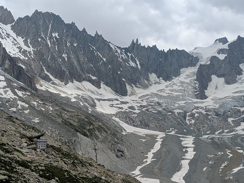
At last the refuge heaves into view, and the cirque (better view of cirque). Pointe Isabella is top right. The refuge you see is the new hut. The old one was underneath the huge tilted rock, hence the name "couvercle" for frying-pan lid. Just over 6 hours total, more than 900 m elevation gain - M was getting fairly tired towards the end.
The hut has character, which is nice, except... well I'll come to that later.
Before it gets dark: explore to find the route down to the glacier. The "obvious" path: head past the old refuge and follow faint tracks doesn't work and ends with an old rope; probably the glacier has retreated too far. Ask at the hut and discover you have to go back down the track a ways to a yellow stick... and find this, further down than I expected.
7/26 Friday: attempt on Pointe Isabella (GPS trace). TL;DR: fail but close. Up 4:30 b'fast leave 5:30 down where I explored y'day to col on moraine down along yellow poles then we're on our own and after the usual brief flailing we're onto ice then snow then gear up. Here we are off the moraine as light begins.

Brief screeching over scoured flattish rocks then pure snow up up. But it's a long way and we shed 150 m going down. Over some big mostly bridged but still quite disturbing crevasses: progress carefully well spread out. Here we're nearly finished with the approach and about to start the route: straight ahead is the icefall which we naturally avoid; we go straightish up the snow then take the ramp R to follow the snow ramp up the rock buttress...

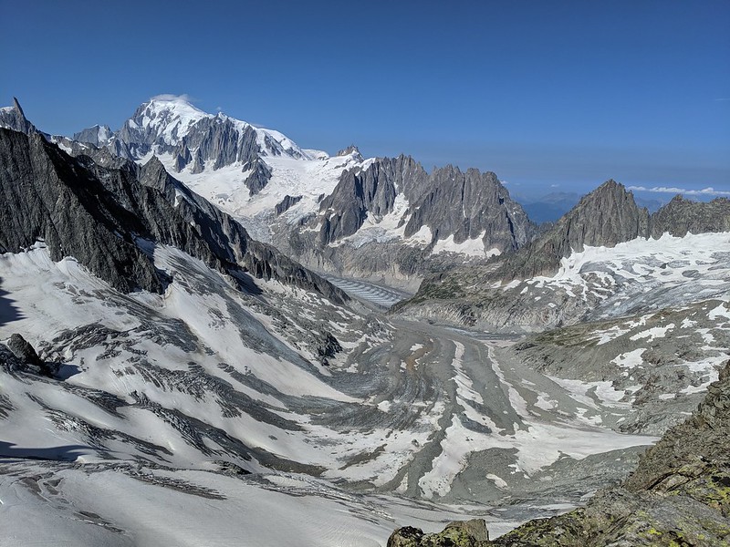
Thence up towards the first snow ridge (not quite visible in this pic) where the guardienne had warned of "glace" - from someone who had done the route a week ago and we've seen little traces - and yes there's about 15 m of 50 deg ice so pitch it cut some steps and put in an ice screw all quite exciting really. Takes an hour and effort though. From the top of the first ridge, we can look back to the herring Mer, across it to Envers, and of course Mt Blanc capped with a little cloud.
Sun on ridge. Up to rock ridge (views of icefall; view on the way down) up that second snow ridge the rock again and we're on the summit slopes but late. Stop at noon maybe 100 m short but f'cast is storms pm and we want to be below difficulties by then, because we're a little un-nerved by that brief ice pitch. And, Miranda is sensible. D and E model Rab.

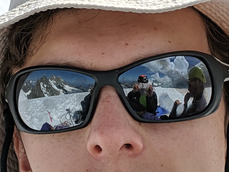
And the view from D's eyes.
Down. Crampons off for longer rock but as usual hard to be sure it is worth it (D and E descending a rock ridge, not sure which one; and on one of the snow ridges). Carefully down ice me last E "falls" once D not and thankfully me not. Here's the icefall with the weather somewhat ominously closing in.

Down carefully crevasses then snow some uncertainty as to track nearly miss path over scrapey rock which E does not like. Rain then hard hail kicks in as we're leaving moraine - again track on rock marked with square but recommended track over moraine not marked. Hut, whew. So we could perhaps have pushed on to the summit, at the cost of getting hailed and rained on quite a lot on the glacier; but some caution is good. Here we're on the last of the snow, with the hut visible opposite if you look closely.

"Add complaint re party here" say my notes. Yeah. So after a pleasant afternoon and meal - at which we were the only guests - we go to bed as good hut-guests do before 10; but then the sound of karaoka comes from downstairs... WTF... eventually I go to investigate / complain but the hut folk (for it is they) are unapologetic and there is nothing to be done. A poor show, but that's Johnny Foreigner for you.
7/27 Saturday: down to the valley (GPS trace with geolocated pix; note the huge jump in the middle is not real) up with alarm 7. Feckless hut folk are unsurprisingly late getting b'fast so pack a bit and look outside waiting. The early light is interesting; our route is down to the moraine, up the LHS snow stripe, round to the L to avoid the wall, then up the snow diagonally R as seen here.

Pano. View of the old hut under it's rock. Hut cat. Let M handle conversation. What lots of people do from here is this: l'Aiguille du Moine, a pure rock route. A pile of people were heading out to it the morning we tried Isabella.

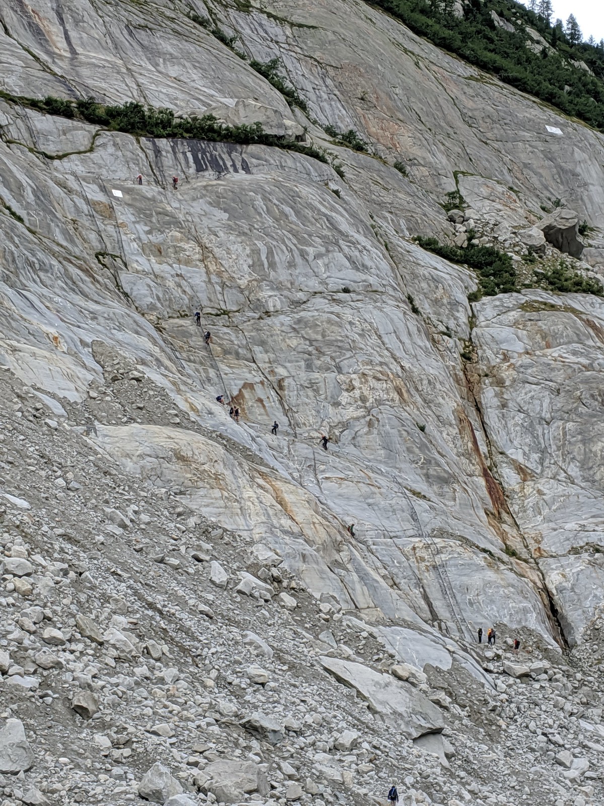
Head down 8:30 and it takes 4+ hours: could be done faster but it is a long but interesting way. Wonder if going via glacier might be better. Don't stop to play on ice cos E's f'cast says rain later and indeed when we get to Montenvers it does start. Here are the ladders down (or in our case up) from the Mer to Montenvers. It's hard to sense the scale but these by comparison with the Couvercle ladders are comparatively short.
Cafe then train down. Car still there - run through rain - up to Argentiere to get keys to appt and settle in. Soir: local pizza.
No comments:
Post a Comment