Day 1: arrival | Day 3: LisenserFernerKogel
Todays activity is available as a GPS track if you want to play along. I also found someone's map, which may help.
It is a relaxed morning: breakfast at 6:30, off about 7:30 up the valley, put in the right way by the sign at the hut:
The FSH (like many huts in the Stubai) is at the head of a hanging valley and there is a pleasant meadow behind it; ending in a step which takes you up 50 m to a further plain; Here is looking back to the hut from the top of the step (and another, taken as we were going back including the top-of-step cairn). Somewhere around here I saw a marmot or two.
The Old Route used to go along the beautiful sharp crest of the moraine, which you can see in my pic, and more clearly in the close up (also in this view up the moraine; the Turm is off to the right and the ApleinerFerner stretches off ahead). Perhaps it has now fallen in, but anyway the route markers now direct you more in the valley bottom and climb up besides the waterfall from the glacier before pushing you up to the top of the moraine near the offshoot to the Aperer Freiger; from the top there is a sign telling you not to take the moraine path on the way down.
Until this point we haven't decided where to go. I rather fancy the Wildgratscharta, which is a steepish col on the glacier allowing you to look over the Schrankogl (which I once, rahter unwisely, tried to climb; but wisely I backed off). M isn't keen on the glacier, though it looks gorgeous to me, so instead we decide on the Aperer Turm, which is one of the two "tourist peaks" from the FSH. This one is just under 3000 m; the other, the RinnenSpitze, is just over.
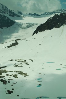 Then you go over the shoulder (quick shot of the path, lower down, where it is just rocky; there is a bonus free Ptarmigan in there if you look closely) that descends from the Vordere and Wilder Turm - the inlined pic is from the Aperer Turm looking back to the shoulder, the black ridge descends from the Vordere Turm, the "icefall" in the background is the AlpeinerFerner, and you can see my tracks in the snow. Miriam stopped at the rocks on the shoulder, and there is a good reason for this: the route is actually a bit cruel, in my opinion, because once you've slogged up to the shoulder (2892 m), confident (from your casual reading of the map) that you're nearly there, you then discover you have to descend 100 m to the lake - shown frozen in the pic - before going up another 200 m to the actual Aperer Turm, 2984 m. While I was on top, I saw two other bods walk up as far as M but come no further; later, she told me they said "it can't be up there!" when she told them they still had 200 m to go. Some route guidance: a view from the shoulder around the lake and up to the ridge on top of the Turm, with the path marked. You'll notice that it is all snow; it won't look like this when you get there.
I should point out that it is all much much snowier in this pic than usual, because we're early in the season and its a snowy season. Here is an annotated view from 2009, seen from the Vordere Sommerwand across the valley (and I'm not totally confident about the Schrandele in that; its remarkably hard to correctly identify mountains). The view form the valley is annotated here - the Turm is actually the first peak on the skyline, though that isn't obvious when you're walking up.
Just to show quite how snowy it was, here is M sunk waist deep just before we get back to the moraine path on the way down; the mass hulking above is the ridge from the Vordere Turm; the snow patches top right are the shoulder leading up to the lake.
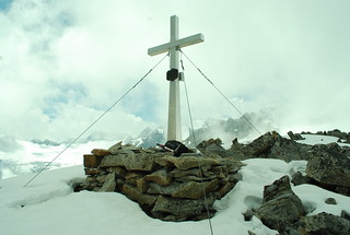
 The Austrians being Austrians, there is a summit cross or GipfelKreuze on the Turm (though not on the Vordere Turm, cos that isn't for tourists) and a GipfelBuche for me to write my name in. As you can see, I was the second of the day, and indeed of the season - I told you we were early. Other people write inspiring things like Life is a mountain not a beach.
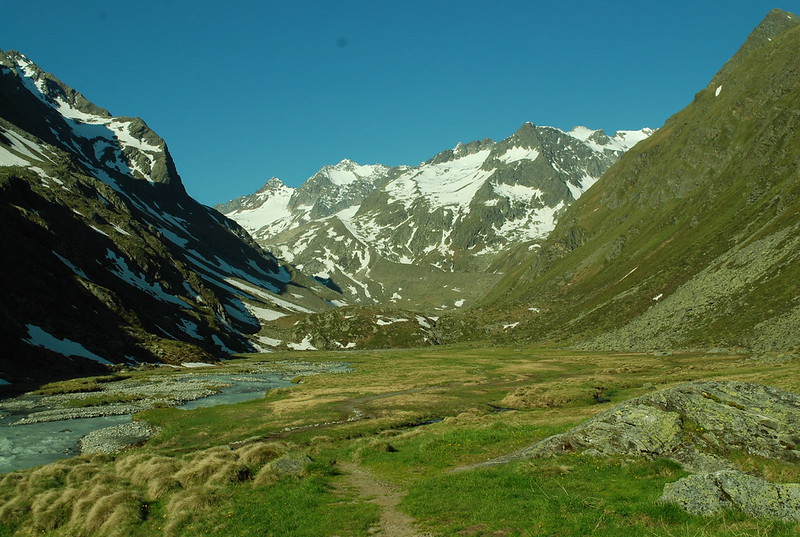
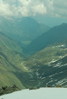
Views from the top are quite decent - here is looking back up the ridge of which the Aperer Turm is the lowest summit; and the other in-lined pic is the view down-valley. This shows you the fairly pronounced step between the ridge and the Turm which you have to negotiate; there are some not-really-needed cables to help you.
And then, back to the hut, in time for afternoon bier (M and Me) and evening meal.
Refs
* Aperer Turm, 2986 m (Bergtour) - in foreign.
* Another one, but with a useful map
No comments:
Post a Comment